Carbon Storage Gulf of Mexico Project
Uncovering hidden potential in US Gulf of Mexico using the power of GeoVerse digital earth science, the Carbon Storage Gulf of Mexico Project provides comprehensive subsurface data over most of the US Gulf of Mexico shallow waters and coastal areas, enabling rapid identification of sweet spots in key carbon storage plays.
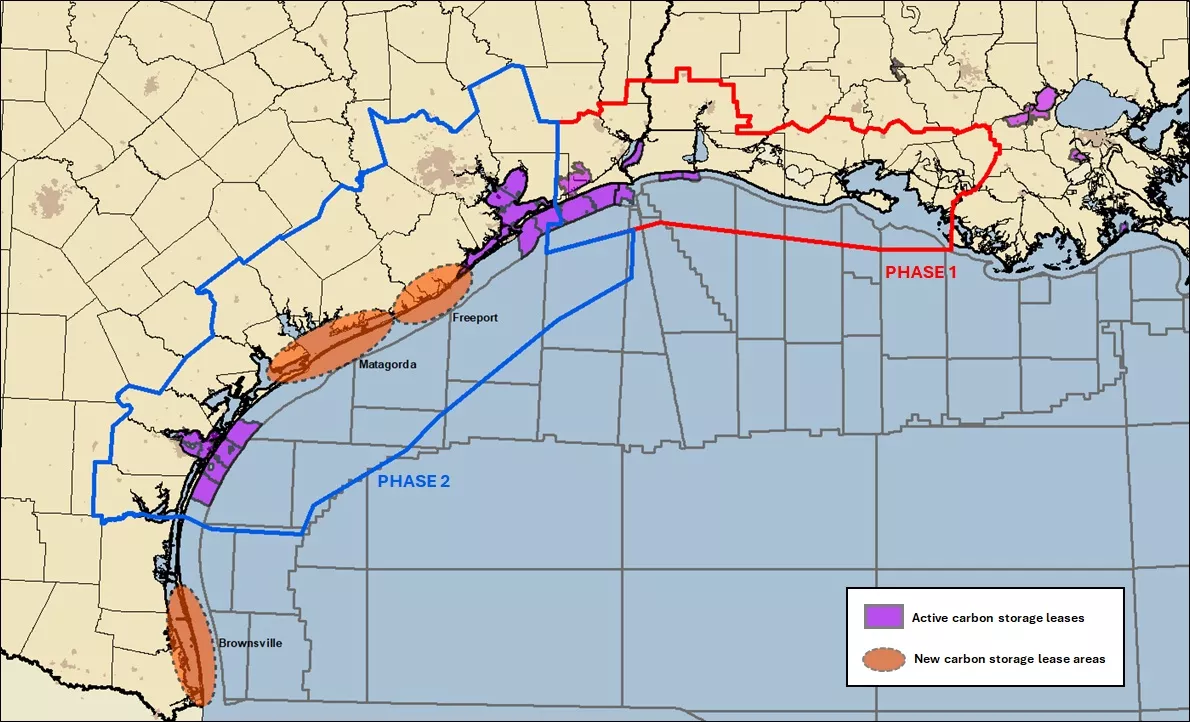
With this cohesive database, operators can accelerate the screening process and identify the most high-potential areas on offer in the upcoming Texas General Land Office and School Land Board Request for Proposals for several carbon sequestration leases.
Carbon Storage Gulf of Mexico Project Details
Project overview
Viridien's Carbon Storage Gulf of Mexico Project provides rich data for carbon storage screening in the shallow water Gulf coast, including a digital well database, an inventory of candidate carbon storage plays and a series of screening maps using Viridien's methodology.
Main features of the project include:
- Focus on the shallow offshore Gulf Coast of Louisiana and Texas
- Foundational geological data from the GeoVerse databases
- Targeted well-screening data collection, collation, digitalization and transformation
- Application of Viridien's proven screening methodology to generate Storage Play Quality Indices (SPQI)
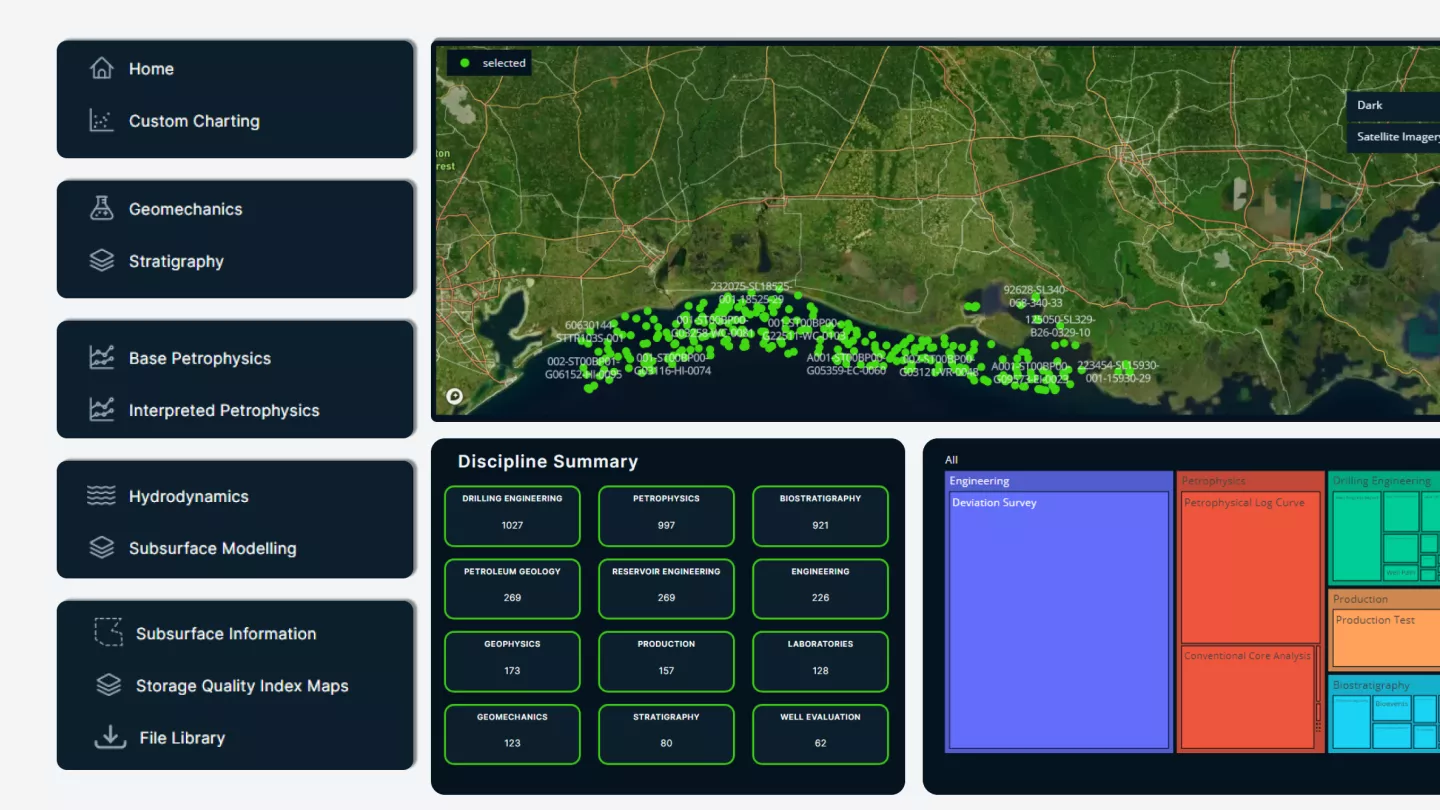
- Online dashboards for pre-set data analytics and index map viewing
What makes our carbon storage screening unique?
Rich digital well database – This subject-matter-expert guided screening of thousands of wells identifies key wells with appropriate data for CCS evaluation, with digital transformation of data from trapped legacy formats into an analytic-ready database. Data is also enhanced from the multidisciplinary processing of the data, always focused on CCS evaluation.
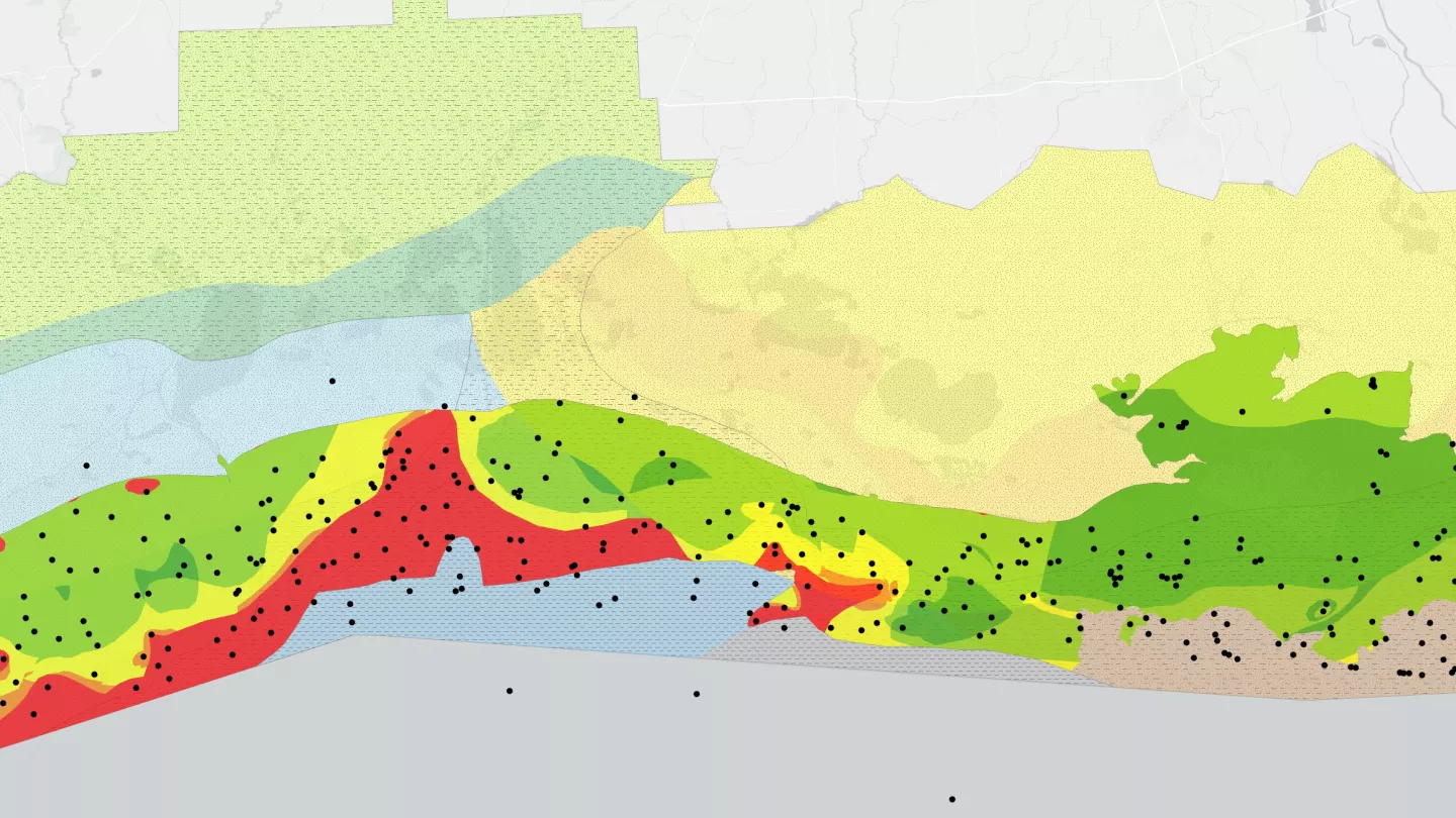
Storage Play Quality Index – The Storage Play Quality Index (SPQI) is Viridien's unique methodology and tool to screen for favorable storage areas within a play at basin scale. It relies on the combination of several key subsurface parameters, including reservoir and seal geological characteristics, but also more importantly their petrophysical and geomechanical properties, as well as the aquifer geochemistry.
Why choose our carbon storage solutions for the Gulf of Mexico?

Data
The Carbon Storage Gulf of Mexico Project s sourced by fully digitized well data, including wireline and petrophysical logs, tabulated point data with depth references such as pressure, temperature, core data and more. The data is structured using GeoVerse taxonomy that underpins all of GeoVerse applications to ensure full multi-disciplinary integration.

Interpretation
Using a multi-faceted approach, the Carbon Storage Project contains a unique set of Storage Play Quality Index (SPQI) maps to help de-risk potential sites in US Gulf of Mexico region. The end-user has access to 42 individual parameter index, including combined SPQI maps for each of 3 plays which have been identified by Viridien experts as favorable targets for CO2 sequestration.

Cloud-Hosted Access
We've developed the cloud-hosted GeoVerse Xplorer platform to make it easier to access licensed data. Simply login and click on Carbon Storage to access the data. You have the ability to view and interpret online or download the files to use them in a GIS-compliant software of your choosing.