Laconia 3D Sparse OBN Survey - US Gulf
Advanced imaging for complex geology
The Laconia 3D sparse Ocean Bottom Node (OBN) survey represents a bold step forward in seismic innovation, engineered to meet the evolving demands of today’s energy sector.
As exploration targets grow deeper and more complex, Laconia delivers the clarity, confidence, and insight needed to drive smarter decisions—from frontier exploration to field development.
Spanning over 620 Outer Continental Shelf (OCS) blocks across the Garden Banks and Keathley Canyon areas, this is the long-offset largest low-frequency sparse OBN survey ever conducted in the region. It stands as a flagship example of how integrated acquisition, imaging, and delivery can come together in a single, high-impact solution.

Highlights
- Comprehensive coverage: Spans over 620 OCS blocks, approximately 14,500 km2
- Phase I: Fast-track data available now, and final data to be delivered May 2026
- Phase II: Fast-track data available now, and final data to be delivered Jul 2026
- Phase III: Fast-track data to be delivered Q1 2026, and final data to be delivered Jan 2027
- Momentum survey data seamlessly integrated into phases I and II
- Extra-long-offset, full-azimuth sparse OBN acquisition enhances diving wave penetration and subsurface illumination below the salt and down to basement.
- Sercel TPS™ (Tuned Pulse Source) is a breakthrough low-frequency broadband marine seismic source that enhances low-frequency content and improves the signal-to-noise ratio, which is critical for maximizing the resolving power of state-of-the-art FWI algorithm.
- Time-Lag Full Waveform Inversion (TL-FWI) produces a more accurate subsalt velocity model and delivers high-resolution imaging. Elastic FWI (E-FWI) further reduces velocity model artefacts, including the halo around sharp impedance contrasts (such as salt-sediment boundaries) and creates a cleaner FWI image.
- Industry-leading High-Performance Computing (HPC) enables scalable, rapid processing.
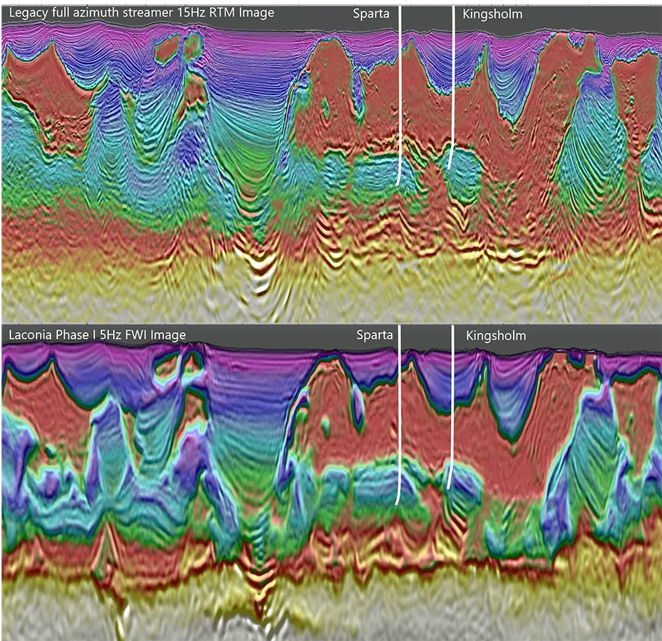
Image caption: Legacy full azimuth streamer 15 Hz RTM image overlaid with 6 Hz streamer FWI velocity (top) and Laconia Phase I long-offset low-frequency sparse OBN “early-out” 5 Hz FWI Image overlaid with corresponding velocity (bottom). The early-out demonstrates significantly improved imaging of the salt and the deep basin architecture, including potential subsalt reservoir targets in the Paleogene trend. The seismic sections intersect the Sparta discovery and the Kingsholm prospect (a dry well with oil shows).
Driving exploration forward
The dataset is unlocking the Paleogene, the Gulf’s largest undeveloped resource, with imaging that reaches basement-level plays. Early-out results from Phase I have revealed multiple new prospects and significantly improved imaging of salt welds, minibasins, and low-velocity shales. Building on the success of Phases I and II, Viridien, together with our strategic partner TGS, announced the launch of Laconia Phase III in June 2025. Covering approximately 150 Outer Continental Shelf (OCS) blocks in the Keathley Canyon area, Phase III is designed to deliver unprecedented insight into complex subsalt reservoirs. This next phase reaffirms our commitment to pushing the boundaries of seismic imaging and supporting our clients in unlocking new exploration opportunities in one of the world’s most prolific deepwater basins.

Why choose Viridien?
Partner with Viridien for industry-leading seismic data solutions designed to meet the demanding exploration needs of offshore US Gulf. Our advanced imaging technology and expertise, in-house HPC, and deep understanding of the Garden Banks and Keathley Canyon areas ensure you gain the competitive advantage you need for exploration success.
Whether you're evaluating new acreage or optimizing field development, Laconia delivers the data and insights to move forward with confidence.
“We’re seeing things now that we wouldn’t have believed possible 10 years ago.” — Peter Whiting, Head of Geoscience, Viridien
Laconia Project - Integrated and Innovative Technologies
From the highest quality subsurface imaging to innovative low-frequency broadband marine seismic sources and high performance cloud solutions, learn more about the technology breakthroughs used in the exciting Laconia project.

Elastic FWI
Overcome limitations imposed by acoustic assumptions with Viridien's proprietary elastic FWI algorithm that combines an elastic modeling engine with the time-lag cost function.

TPS (Tuned Pulse Source)
Achieve geophysical clarity by improving low frequency content with Sercel's TPS (Tuned Pulse Source) new marine seismic source.

High-Performance Computing and Cloud Solutions
Accelerate your AI, science and engineering with custom High-Performance Computing (HPC) and Cloud solutions.